
Boundary vs Topographic Survey: Key Differences in Toronto
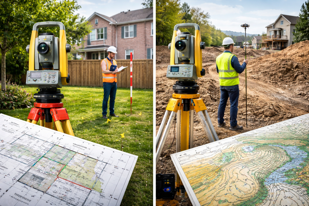
A boundary survey answers one core question: where are the legal limits of ownership? This is one of the most important aspects of land surveying because it defines exactly what belongs to you and where your property legally begins and ends.
The Association of Ontario Land Surveyors (AOLS) frames cadastral surveying as the process of establishing, locating, defining, or describing boundaries and corners of parcels. In Ontario, this work is strictly regulated, and only licensed members are authorized to carry out legal boundary surveys.
This matters because the results are used to support decisions with real legal consequences. A boundary survey is often required in situations involving:
- Encroachments (such as fences, decks, or structures crossing property lines)
- Easements and rights-of-way
- Property severances or lot subdivisions
- Boundary disputes between neighbors
- Real estate transactions and title clarification
Without an accurate and up-to-date boundary survey, property owners risk making decisions that could lead to legal conflicts, delays, or unexpected costs.
Topographic Survey: The “Existing Site Conditions” Layer
A topographic survey focuses on describing the land as it physically exists today, rather than defining ownership boundaries. It provides a detailed representation of the surface and features of a property.
The Association of Ontario Land Surveyors explains that topographic survey plans show existing physical features and are widely used by engineers, architects, and planners to support detailed design work.
These surveys typically include:
- Grade changes and slope information
- Elevation points across the site
- Contour lines showing the shape of the land
- Buildings, driveways, and other structures
- Trees, utilities, and visible site features
Topographic surveys play a key role in the planning and construction process. They are often incorporated directly into engineering and architectural drawings, especially for development applications, renovations, and new construction projects.
By providing accurate elevation and site data, topographic surveys help ensure that designs are functional, safe, and compliant with municipal requirements.
Why People Confuse Them (and Why That Causes Delays)
Homeowners and property owners often request “a survey for my permit,” expecting that a single document will include everything needed for approval. This is a very common misunderstanding.
In reality, a permit submission is not just one document it is a package of coordinated information. Each type of survey serves a different purpose:
- Zoning compliance depends on accurate property boundaries
- Design and construction depend on elevations and site conditions
Guidance from Toronto Building reflects this reality. Permit applications often require:
- Site plans that show property lines referenced to a current survey
- Elevation and grading information to confirm building height and drainage
When the wrong type of survey is requested—or when one is missing—it can lead to:
- Delays in permit approval
- Requests for additional information
- Redesign costs
- Project timeline setbacks
Understanding the difference early helps avoid these issues and keeps projects moving smoothly.
When You Need One, the Other, or Both
Boundary Survey
A boundary survey is needed whenever the exact legal property line is important. This includes:
- Building additions close to lot lines
- Fence installation or replacement
- Property disputes or encroachments
- Land severances and subdivisions
- Verifying legal boundaries before construction
Topographic Survey
A topographic survey is required when design decisions depend on the land itself. This includes:
- Grading and drainage plans
- Entrance and driveway elevations
- Landscape design
- Civil engineering and architectural coordination
- Site servicing and stormwater management
Both (Most Common Scenario)
In many Toronto and GTA projects—especially infill developments—both surveys are required together.
- Boundary information ensures compliance with zoning bylaws, setbacks, and property limits
- Topographic information supports grading, drainage, and overall buildability
Using both surveys together provides a complete understanding of the site, reducing risk and improving project efficiency.
A Practical Toronto/GTA Example: Permit-Ready Site Plans
In Toronto, homeowner guidance clearly distinguishes between a property survey and a site plan.
- A property (boundary) survey is prepared and certified by a licensed surveyor
- A site plan is typically created by a designer, architect, or planner
Importantly, site plans are not sealed by a surveyor, but they must be based on reliable and accurate survey data.
Permit submissions often require:
- Property lines tied to a current boundary survey
- Building location and setbacks
- Elevation and grading details (in certain cases)
This means that while your designer prepares the site plan, the underlying survey data must be accurate and defensible. In many cases, topographic information is also necessary to ensure correct height and grade calculations.
Ready to Get Started?
Ensure your Toronto/GTA project has accurate property lines and detailed site information from the beginning.
Working with a licensed Ontario Land Surveyor helps you:
- Avoid costly mistakes and delays
- Meet municipal requirements
- Ensure legal compliance and design accuracy
Don’t risk setbacks request a quote today for the boundary and topographic surveys you need for smooth permit approval and successful project execution.